| Scenario |
Real-Estate price is often influenced by policy and economy volatilities. Investors and young people who intend to buy houses can cognize the current real-estate price through actual price registration system. Designed for policies of residence justice, the Actual Price Registration System is expected to meet social desirability and improve information asymmetry happening to the current real-estate trading cases.
However, it is still not enough for people to figure out how real-estate prices change just by knowing the price. Su, Jia-Hong, a student in Chien Hsin University of Science and Technology who majors in Applied Geomatics, joined SuperGIS Youth Award, a GIS Competition hold by Supergeo Technologies Inc., and proposed that Geographic Information System can be employed to analyze and demonstrate the result to tell how housing prices rise/fall. |
|
|
|
| Goals |
| Mr. Su employed the GIS desktop software, SuperGIS Desktop, and used real-estate data collected from the Actual Price Registration website, including required coordinates, housing prices, pings of all floors in the building and so forth of Qingpu special district in Taoyuan City. Through data analyses with Interpolation Method, Mr. Su comprehended the process that how housing price changed during 2012 to 2014. |
|
|
| Solutions |
1. Collecting Geographic Data of Qingpu Special District in Taoyuan City:
Qingpu special district, located at the North-West area of Zhongli District and being close to High Speed Rail Station District, has been developed speedily in recent years. It is also known as Taoyuan High Speed Rail Station special district.. |
|
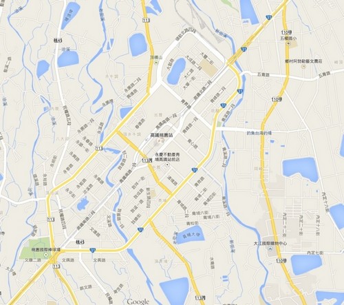
▲ Qingpu Special Distric Map
|
|
2. Collecting Housing Data and Creating Information Files:
Mr. Su collected housing data on the Internet. The Actual Price Registration website provides trading information of the recent two years, including trading year and month, house address, total price, unit price of each ping, floor area, plot of land, age of houses, the number of floors, housing pattern, etc. This research applied information of houses that located within 2 kilometers from Qingpu Special District in Taoyuan City and have been traded successfully during the last two years. All the picked houses are aged or less than 10 years old; and most of them are new ones. However, the housing prices are different with the floor that each apartment loacted on; therefore, Mr. Su selected mid-level apartments for the research while necessary. In addition, he also converted houses’ coordinates to geographic coordinates and then TM coodinates for his 2012 and 2013 house information reports, which includes houses’ coordinates, address, unit price of each ping and the trading date. |
|
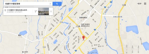
▲Querying Coordinates by Address
|
|
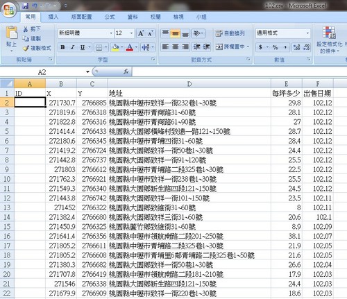
▲Reports of House Information
|
|
|
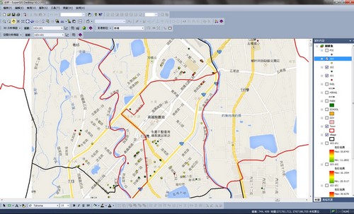
3. Importing Data into SuperGIS Desktop:
Using the toolbar on SuperGIS Desktop, Mr. Su mashed up hose data and the XY data to create different point layers of 2012, 2013 and 2014, and rectified images cached from GoogleMap by Data Rectifier (Tool). We can see the red points represent position of houses that were traded in 2012, green ones in 2013 and yellow ones in 2014. |
|
|
|
|
|
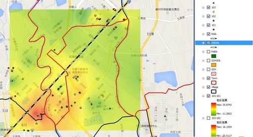
4. Inverse Distance Weighted (IDW) Function:
Subsequently, Mr. Su employed Inverse Distance Weighted (IDW) function of Spatial Analyst within SuperGIS Desktop, imported point data into house data layers of 2012, 2013 and 2014, entered unit price of each ping as Z value and export as a raster file. On the maps which show the results of IDW analysis, we can see that the red part means area having houses with high prices; the green part means converse situation. |
|
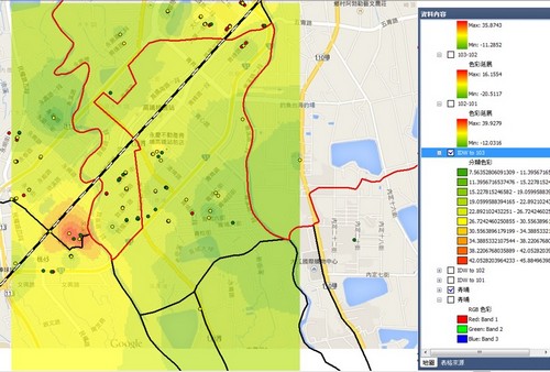
▲Inverse Distance Weighted (IDW) Analysis for 2014 Data
|
|
|
| Results |
| According to the result of interpolation method through IDW function of Spatial Analyst within SuperGIS Desktop, Mr. Su found that price of houses in the area near to south of High Speed Rail Station increased obviously in 2012 and 2013; moreover, from 2013 to 2014, the price of all houses around the High Speed Rail Station increased. After comparing data 2012 with data 2014, he found that unit price of each ping increased a lot during 2 years. |
|
▲Data 2012 and 2013 Comparison Result
|
|
|
| Benefits |
The student, Lin, of Chien Hsin University of Science and Technology used SuperGIS Desktop to access data he collected and utilized SuperGIS Analyst to conduct spatial analyses; afterwards, SuperGIS Desktop can demonstrate the analysis results to help Su map the required data and provide powerful evidence for his research. In this way, Su can observe the process of housing price change through GIS to comprehend the price trend and the relation among housing price, environment around and spatial changes.
Source |
|
|
|

Δεν υπάρχουν σχόλια:
Δημοσίευση σχολίου