
How to obtain free LiDAR data online
Does it feel like a big challenge to find LiDAR data sources?
How about free LiDAR data sources?
We understand. LiDAR is a beast of a dataset to work with. What other GIS formats have its OWN compression format (LAZ). C’mon! Have you ever seen a shapefile with its OWN compression format?
This fact alone makes LiDAR repositories national treasures in GIS.
So as Dr. Evil would say *pinky in the mouth*

"BRING OUT THE LASER"
(Laser for LiDAR, of course).
We’re bringing out the lasers in this special post on free LiDAR data sources. Enjoy.
1. Open Topography
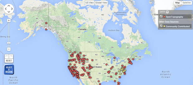
Open Topography has made our 10 best free global raster and vector data sources. So why not have them at #1 in a list specializing in LiDAR data sources?
If you don’t know about Open Topography, you should probably take a peek. The beauty behind Open Topography is its open community system. Users register their data so that the larger community can access it. You too can help grow Open Topography into one of the biggest open data portals for free LiDAR data. Pretty neat.
- Open Topography is a collaborative data repository for LiDAR users.
- Intuitive web map displays LiDAR points as downloadable data with metadata
2. USGS Earth Explorer

Previously, USGS LiDAR data could be accessed through CLICK (Center for LiDAR Information Coordination and Knowledge). However, this service is now being provided by the USGS Earth Explorer.
So you want USGS Earth Explorer LiDAR data? Here’s how: 1) Enter your search criteria (kml, coordinates, etc.). 2) In the data sets tab, select the checkbox for LiDAR. 3) Click the results tab to see what LiDAR datasets are available.
- Search for LiDAR data with a user-friendly state-of-the-art interface
- Filter searches by time and set region of interests in map by predefine areas and coordinates
3. United States Interagency Elevation Inventory + Wikipedia LiDAR

There’s been a movement in the United States for a National LiDAR Dataset. This innitiative is being led by the United States Interagency Elevation Inventory (USIEI) in collaboration with NOAA and USGS.
Several states have moved forward in their own collections. To see exactly which states they are, the USIEI Inventory gives you this information along with vertical accuracy, point spacing, and date of collection. Downloading the physical data is not so straight-forward. The National LiDAR Dataset Wikipedia page maintains download source locations.
- LiDAR sources are decentralized with partial and incomplete data across the United States
- USIEI LiDAR data viewer displays the nationwide listing of known high-accuracy topographic data
4. NOAA Digital Coast

NOAA’s mission (in the sense of LiDAR data) is clear. They want to capture coastalarea LiDAR data. This data is then served to the public.
NOAA’s Digital Coast webmap gives you the ability to know exactly where coastal LiDAR is located in the United States. This makes your search for coastal LiDAR data a no-brainer. Go with NOAA.
- Slick web application to search, analyze and download free LiDAR data.
- Draw area of interest and click LiDAR data download.
5. LIDAR Online

Who knows? This may be where the future of LiDAR is going – a global LiDAR map. Don’t laugh. We have the Earth mapped with optical imagery already.
LiDAR Online’s mission is ambitious. No matter where you live, this data source shows you exactly where on Earth is LiDAR. Admittedly, a little bare now in terms of LiDAR sources, LiDAR Online shows a lot of promise.
- LiDAR spans the globe – mostly Europe, North and South America and Africa.
- Webmap with points delineating free LiDAR data sources.
6. National Ecological Observatory Network – NEON

One of the cool things about the National Ecological Observatory Network (NEON) is that they are funded by the National Science Foundation. Another neat thing about NEON is the amazing work they are doing with airborne LiDAR to map out vegetation stands.
Although some of NEON’s data may not have sufficient QA/QC to meet the end-user’s needs, we still think NEON’s airborne LiDAR data has some serious potential.
- Minimal selection of LiDAR because in construction phase
- Beginning of a collection of publicly available LiDAR
Do you remember when you thought free LiDAR data was hard to come by?
We’ve provided you with 6 free LiDAR data sources options.
Instantly, you’ve mastered the art of attaining LiDAR point cloud data at no cost.
Δεν υπάρχουν σχόλια:
Δημοσίευση σχολίου