
The Hunt for Survey Benchmark Monument Locations
If you’re serious about geocaching, than you’ve probably heard of benchmark hunting.
But just what is a survey benchmark?
Survey benchmark monuments are brass or metal disks in the ground. They measureexact horizontal positions (latitude and longitude) on the Earth because this gives surveyors a point of reference. Some benchmarks also measure elevations. These types of benchmarks indicate the height above or below sea level at that location.
There’s a buzz around benchmarks in the geocaching community because there’s almost a hidden history behind them. When you find a survey benchmark, you may be looking at benchmark surveyed more than a century ago. Benchmarks are a part of human history. They mark our curiosity, exploration and discovery.
A “benchmark” is a generic term sometimes referred as survey marks, geodetic marksand control stations. However, survey professionals prefer the terms station or markrather than benchmark to describe horizontal control marks.
Developing a Datum Using Triangulation

Survey Benchmark Monument
With 2 benchmark locations, triangulation and trigonometry are used to measure the direction, distance and elevation between them. This is called geodetic leveling. Geodetic leveling can even be used to understand the area and volume of the Earth.
Horizontal control data provide a rigid framework for map makers, engineers and land surveyors in North America. It makes it possible for greater precision for surveys and locate national, state, county and private boundaries with greater precision. Benchmarks are important to surveyors because they help accurately measure the positions of all land boundaries and modern infrastructure.
More recently, survey markers are now often used to set up a GPS receiver antenna in a known position for use in Differential GPS surveying.
Who is Responsible for Survey Benchmark Monuments?
In the United States, NOAA’s National Geodetic Survey (NGS) is responsible for managing approximately 240,000 stations gathered over the last two centuries. This survey benchmark data is made available through the National Geodetic Survey Data Explorer.
NGS developed the North American Datum of 1927 that was defined by the Clarke spheroid of 1866, with its origin at (the survey station) Meades Ranch. A more accurate datum was created called North American Datum of 1983 (NAD 83). This horizontal control datum is used in the United States, Canada, Mexico, and Central America, based on a geocentric origin and the Geodetic Reference System 1980.
In Canada, Natural Resources Canada’s Geodetic Reference System is responsible for the maintenance of survey benchmarks. In the United Kingdom, it’s the Ordnance Survey and in France, it’s Institut Géographique National.
What Types of Benchmarks Exist?

Hawaii Triangulation Station
INTERSECTION STATIONS are horizontal control marks with a landmarks that can be seen from a distance. Examples of intersection stations are water or radio towers. These points can be observed with a telescope using trigonometry to determine their position on Earth.
TRIANGULATION STATIONS are markers with positions determined by measuring distances and angles from other stations. Reference marks help keep triangulation stations from being lost with arrows on their disks pointing in the direction of their referenced triangulation station. Azimuth marks, coupled with its triangulation station, provides a compass direction of the true north (which is different from the magnetic North).
Here are the horizontal and vertical geodetic control stations for the Hawaiian Islands by the National Geodetic Survey. Source: National Geodetic Survey
NOAA Geodetic Control Points Data Explorer

National Geodetic Survey Explorer
From coast-to-coast dating back to 1832, benchmarks have been surveyed using a range of different techniques. Surveyors installed survey benchmarks systematically across the region. New distances and angles were always being recorded between points.
Each survey benchmark is stored in the NGS database with its own unique personal identifier (PID) six character alphanumeric code, latitude and longitude.
Types of NOAA Control Points

NOAA Control Station
Here are the various types of NOAA control points:
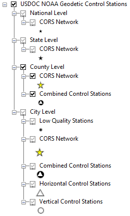
CONTINUOUSLY OPERATING REFERENCE STATIONS (CORS) NETWORK are control stations with permanently operating Global Positioning System (GPS) receivers. In the NOAA control point dataset, they are identified by the attribute DATUM_TAG = ‘(CORS)’.
COMBINED CONTROL STATIONS are horizontal and vertical control stations.
LOW QUALITY STATIONS have low quality latitude, longitudes (horizontal) and/or low quality Orthometric Heights (vertical). Low horizontal quality have the following attributes: POS_SRCE = ‘GPS_OBS’, ‘NO CHECK’, ‘HD_HELD1’, ‘HD_HELD2’, or ‘SCALED’. Low vertical quality have the following attributes: “ELEV_SRCE” = ‘GPSCONLV ‘, ‘VERT ANG’, ‘H LEVEL’, ‘VERTCON’, or ‘SCALED’.
HORIZONTAL CONTROL STATIONS only contain precise latitudes and longitude. They the attribute POS_SRCE = ‘ADJUSTED’.
VERTICAL CONTROL STATIONS have precise Orthometric Heights which measure elevation in meters indicating the height above the Geoid. They have the following attributes: ELEV_SRCE = ‘ADJUSTED’, ‘ADJ UNCH’, ‘POSTED’, ‘READJUSTED’, ‘N HEIGHT’, ‘RESET’, ‘GPS OBS(2006’, ‘LEVELING’), or ‘LEVELING(200)’.
Note: A single station can be classified in multiple ways – as an example having low quality Orthometric Height and be part of the CORS network.
Geocaching for Survey Monuments (Benchmarking)

Geocaching Logo
Why do geocachers seek survey benchmark points?
When you search for a survey benchmark, you really get to see a piece of history. Some of these points haven’t been visited for decades, even centuries. When you find these hidden gems placed into the ground years ago, they can be documented and shared with the geocaching community. And you have bragging rights in the community.
Seek out the nearest survey monument to you. Geocache and discover the history of classical surveying.
Δεν υπάρχουν σχόλια:
Δημοσίευση σχολίου